|
| at: |
South Fork |
Data from David Muse
 show on map
 animate
Trail users:


Elevation Profile
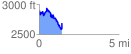
 1.442949 mi
 379.21 ft
 589.92 ft
 -210.71 ft
 7.74 %
GPX Downloads: Track Route
![]()
|
| at: |
South Fork |
show on map
animate
1.442949 mi
379.21 ft
589.92 ft
-210.71 ft
7.74 %