| at: |
Cashes Valley Trans North Georgia |
Data from David Muse
 show on map
 animate
Trail users:


Elevation Profile
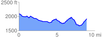
 8.998685 mi
 733.88 ft
 944.28 ft
 -210.39 ft
 1.99 %
GPX Downloads: Track Route
![]()
| at: |
Cashes Valley Trans North Georgia |
show on map
animate
8.998685 mi
733.88 ft
944.28 ft
-210.39 ft
1.99 %