| at: |
Chestatee WMA Lake Winfield Scott |
Data from David Muse
 show on map
 animate

Trail users:

Elevation Profile
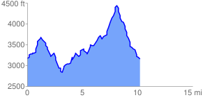
 10.501065 mi
 3388.41 ft
 3459.18 ft
 -70.77 ft
 6.24 %
GPX Downloads: Track Route
Trailheads:
 AT - Neels GapAT - Woody Gap