| at: |
Chestatee WMA |
Data from David Muse
 show on map
 animate
Trail users:

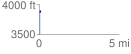
Elevation Profile
 0.091635 mi
 32.20 ft
 2.61 ft
 29.59 ft
 6.65 %
GPX Downloads: Track Route
![]()
| at: |
Chestatee WMA |
show on map
animate
0.091635 mi
32.20 ft
2.61 ft
29.59 ft
6.65 %