|
| at: |
Chestatee WMA Lake Winfield Scott |
Data from David Muse
 show on map
 animate
Trail users:


Elevation Profile
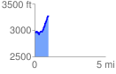
 0.985159 mi
 439.38 ft
 121.78 ft
 317.60 ft
 8.45 %
GPX Downloads: Track Route
![]()
|
| at: |
Chestatee WMA Lake Winfield Scott |
show on map
animate
0.985159 mi
439.38 ft
121.78 ft
317.60 ft
8.45 %