| at: |
Bremen and Carrollton Area Roads |
Data from David Muse
 show on map
 animate
Trail users:


Elevation Profile
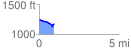
 0.946980 mi
 52.62 ft
 120.59 ft
 -67.97 ft
 2.41 %
GPX Downloads: Track Route
![]()
| at: |
Bremen and Carrollton Area Roads |
show on map
animate
0.946980 mi
52.62 ft
120.59 ft
-67.97 ft
2.41 %