| at: |
Chestatee WMA |
Data from David Muse
 show on map
 animate
Trail users:


Elevation Profile
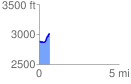
 0.653921 mi
 143.48 ft
 25.25 ft
 118.23 ft
 4.16 %
GPX Downloads: Track Route
![]()
| at: |
Chestatee WMA |
show on map
animate
0.653921 mi
143.48 ft
25.25 ft
118.23 ft
4.16 %