| at: |
West Georgia Pinhoti |
Data from David Muse
 show on map
 animate
The section east of Huffaker Road (the last road crossing) gets little use and ends abruptly, in someone's front yard.
Fortunately, their dogs are reasonably friendly.


Elevation Profile
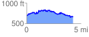
 4.299967 mi
 563.04 ft
 597.54 ft
 -34.50 ft
 2.63 %
GPX Downloads: Track Route