| at: |
Olde Rope Mill Park |
Data from David Muse
 show on map
 animate
Trail users:


Elevation Profile
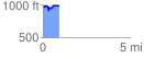
 0.926738 mi
 119.87 ft
 132.13 ft
 -12.26 ft
 2.70 %
GPX Downloads: Track Route
![]()
| at: |
Olde Rope Mill Park |
show on map
animate
0.926738 mi
119.87 ft
132.13 ft
-12.26 ft
2.70 %