| at: |
Pinelog WMA |
Data from David Muse
 show on map
 animate
Trail users:


Elevation Profile
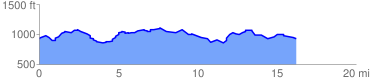
 16.507532 mi
 1118.19 ft
 1119.74 ft
 -1.56 ft
 1.28 %
GPX Downloads: Track Route
![]()
| at: |
Pinelog WMA |
show on map
animate
16.507532 mi
1118.19 ft
1119.74 ft
-1.56 ft
1.28 %