| at: |
Pinelog WMA |
Data from David Muse
 show on map
 animate
Trail users:


Elevation Profile
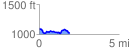
 1.915201 mi
 165.77 ft
 245.57 ft
 -79.80 ft
 2.43 %
GPX Downloads: Track Route
![]()
| at: |
Pinelog WMA |
show on map
animate
1.915201 mi
165.77 ft
245.57 ft
-79.80 ft
2.43 %