| at: |
Cashes Valley |
Data from David Muse
 show on map
 animate
Trail users:


Elevation Profile
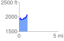
 1.058921 mi
 243.04 ft
 88.42 ft
 154.62 ft
 4.35 %
GPX Downloads: Track Route
![]()
| at: |
Cashes Valley |
show on map
animate
1.058921 mi
243.04 ft
88.42 ft
154.62 ft
4.35 %