| at: |
Rock Creek/Tatum Lead ORV Trails Cohutta Pinhoti Trans North Georgia Mulberry Gap |
Data from David Muse
 show on map
 animate
Trail users:


Elevation Profile
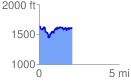
 2.049788 mi
 390.08 ft
 439.09 ft
 -49.01 ft
 4.06 %
GPX Downloads: Track Route