| at: |
Bremen and Carrollton Area Roads |
Data from Georgia DOT
 show on map
 animate
Trail users:


Elevation Profile
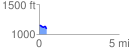
 0.493523 mi
 12.06 ft
 73.39 ft
 -61.33 ft
 2.82 %
GPX Downloads: Track Route
![]()
| at: |
Bremen and Carrollton Area Roads |
show on map
animate
0.493523 mi
12.06 ft
73.39 ft
-61.33 ft
2.82 %