| at: |
Bremen and Carrollton Area Roads |
Data from Georgia DOT
 show on map
 animate
Trail users:


Elevation Profile
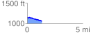
 1.304239 mi
 28.84 ft
 117.57 ft
 -88.73 ft
 1.71 %
GPX Downloads: Track Route
![]()
| at: |
Bremen and Carrollton Area Roads |
show on map
animate
1.304239 mi
28.84 ft
117.57 ft
-88.73 ft
1.71 %