| at: |
Bremen and Carrollton Area Roads |
Data from Georgia DOT
 show on map
 animate
Trail users:


Elevation Profile
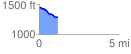
 1.180651 mi
 32.55 ft
 172.98 ft
 -140.43 ft
 2.77 %
GPX Downloads: Track Route
![]()
| at: |
Bremen and Carrollton Area Roads |
show on map
animate
1.180651 mi
32.55 ft
172.98 ft
-140.43 ft
2.77 %