| at: |
Bremen and Carrollton Area Roads |
Data from Georgia DOT
 show on map
 animate
Trail users:


Elevation Profile
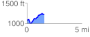
 1.556721 mi
 285.59 ft
 149.51 ft
 136.08 ft
 3.47 %
GPX Downloads: Track Route
![]()
| at: |
Bremen and Carrollton Area Roads |
show on map
animate
1.556721 mi
285.59 ft
149.51 ft
136.08 ft
3.47 %