| at: |
Bremen and Carrollton Area Roads |
Data from Georgia DOT
 show on map
 animate
Trail users:


Elevation Profile
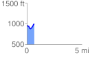
 0.651728 mi
 113.29 ft
 88.50 ft
 24.79 ft
 3.29 %
GPX Downloads: Track Route
![]()
| at: |
Bremen and Carrollton Area Roads |
show on map
animate
0.651728 mi
113.29 ft
88.50 ft
24.79 ft
3.29 %