| at: |
Bremen and Carrollton Area Roads |
Data from Georgia DOT
 show on map
 animate
Trail users:


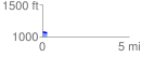
Elevation Profile
 0.276305 mi
 3.24 ft
 12.80 ft
 -9.56 ft
 0.88 %
GPX Downloads: Track Route
![]()
| at: |
Bremen and Carrollton Area Roads |
show on map
animate
0.276305 mi
3.24 ft
12.80 ft
-9.56 ft
0.88 %