| at: |
Bremen and Carrollton Area Roads |
Data from Georgia DOT
 show on map
 animate
Trail users:


Elevation Profile
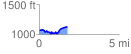
 1.761651 mi
 212.62 ft
 166.03 ft
 46.58 ft
 2.29 %
GPX Downloads: Track Route
![]()
| at: |
Bremen and Carrollton Area Roads |
show on map
animate
1.761651 mi
212.62 ft
166.03 ft
46.58 ft
2.29 %