| at: |
Bremen and Carrollton Area Roads |
Data from Georgia DOT
 show on map
 animate
Trail users:


Elevation Profile
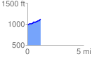
 1.167360 mi
 137.96 ft
 24.76 ft
 113.20 ft
 2.24 %
GPX Downloads: Track Route
![]()
| at: |
Bremen and Carrollton Area Roads |
show on map
animate
1.167360 mi
137.96 ft
24.76 ft
113.20 ft
2.24 %