| at: |
Bremen and Carrollton Area Roads |
Data from Georgia DOT
 show on map
 animate
Trail users:


Elevation Profile
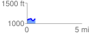
 0.761064 mi
 74.98 ft
 61.82 ft
 13.15 ft
 1.87 %
GPX Downloads: Track Route
![]()
| at: |
Bremen and Carrollton Area Roads |
show on map
animate
0.761064 mi
74.98 ft
61.82 ft
13.15 ft
1.87 %