| at: |
Bremen and Carrollton Area Roads |
Data from Georgia DOT
 show on map
 animate
Trail users:


Elevation Profile
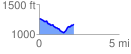
 2.154001 mi
 170.38 ft
 266.67 ft
 -96.30 ft
 2.34 %
GPX Downloads: Track Route
![]()
| at: |
Bremen and Carrollton Area Roads |
show on map
animate
2.154001 mi
170.38 ft
266.67 ft
-96.30 ft
2.34 %