| at: |
Bremen and Carrollton Area Roads |
Data from Georgia DOT
 show on map
 animate
Trail users:


Elevation Profile
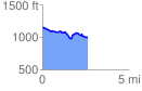
 2.606087 mi
 136.58 ft
 305.34 ft
 -168.76 ft
 2.22 %
GPX Downloads: Track Route
![]()
| at: |
Bremen and Carrollton Area Roads |
show on map
animate
2.606087 mi
136.58 ft
305.34 ft
-168.76 ft
2.22 %