| at: |
Bremen and Carrollton Area Roads |
Data from Georgia DOT
 show on map
 animate
Trail users:


Elevation Profile
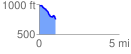
 1.023393 mi
 24.14 ft
 264.48 ft
 -240.34 ft
 4.89 %
GPX Downloads: Track Route
![]()
| at: |
Bremen and Carrollton Area Roads |
show on map
animate
1.023393 mi
24.14 ft
264.48 ft
-240.34 ft
4.89 %