| at: |
Bremen and Carrollton Area Roads |
Data from Georgia DOT
 show on map
 animate
Trail users:


Elevation Profile
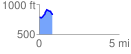
 0.840788 mi
 144.64 ft
 120.03 ft
 24.62 ft
 3.26 %
GPX Downloads: Track Route
![]()
| at: |
Bremen and Carrollton Area Roads |
show on map
animate
0.840788 mi
144.64 ft
120.03 ft
24.62 ft
3.26 %