| at: |
Pinelog WMA |
Data from David Muse
 show on map
 animate
Trail users:


Elevation Profile
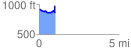
 1.003319 mi
 153.28 ft
 207.67 ft
 -54.39 ft
 3.92 %
GPX Downloads: Track Route
![]()
| at: |
Pinelog WMA |
show on map
animate
1.003319 mi
153.28 ft
207.67 ft
-54.39 ft
3.92 %