| at: |
Tombigbee National Forest - South |
Data from USFS GIS
 show on map
 animate
Trail users:


Elevation Profile
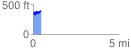
 0.454512 mi
 145.15 ft
 93.86 ft
 51.28 ft
 6.05 %
GPX Downloads: Track Route
![]()
| at: |
Tombigbee National Forest - South |
show on map
animate
0.454512 mi
145.15 ft
93.86 ft
51.28 ft
6.05 %