| at: |
Tombigbee National Forest - South |
Data from USFS GIS
 show on map
 animate
Trail users:


Elevation Profile
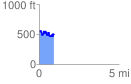
 0.947483 mi
 280.92 ft
 345.53 ft
 -64.61 ft
 6.91 %
GPX Downloads: Track Route
![]()
| at: |
Tombigbee National Forest - South |
show on map
animate
0.947483 mi
280.92 ft
345.53 ft
-64.61 ft
6.91 %