|
| at: |
Tombigbee National Forest - South |
Data from USFS GIS
 show on map
 animate
Trail users:


Elevation Profile
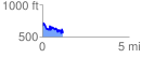
 1.169823 mi
 299.08 ft
 428.71 ft
 -129.63 ft
 6.94 %
GPX Downloads: Track Route
![]()
|
| at: |
Tombigbee National Forest - South |
show on map
animate
1.169823 mi
299.08 ft
428.71 ft
-129.63 ft
6.94 %