| at: |
Tombigbee National Forest - South |
Data from USFS GIS
 show on map
 animate
Trail users:


Elevation Profile
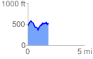
 1.829212 mi
 390.70 ft
 368.87 ft
 21.83 ft
 4.05 %
GPX Downloads: Track Route
![]()
| at: |
Tombigbee National Forest - South |
show on map
animate
1.829212 mi
390.70 ft
368.87 ft
21.83 ft
4.05 %