| at: |
Tombigbee National Forest - South |
Data from USFS GIS
 show on map
 animate
Trail users:


Elevation Profile
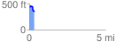
 0.329771 mi
 42.97 ft
 111.07 ft
 -68.10 ft
 6.38 %
GPX Downloads: Track Route
![]()
| at: |
Tombigbee National Forest - South |
show on map
animate
0.329771 mi
42.97 ft
111.07 ft
-68.10 ft
6.38 %