|
| at: |
Tombigbee National Forest - South |
Data from USFS GIS
 show on map
 animate
Trail users:


Elevation Profile
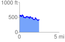
 2.508004 mi
 423.56 ft
 537.79 ft
 -114.23 ft
 4.06 %
GPX Downloads: Track Route
![]()
|
| at: |
Tombigbee National Forest - South |
show on map
animate
2.508004 mi
423.56 ft
537.79 ft
-114.23 ft
4.06 %