| at: |
Tombigbee National Forest - South |
Data from USFS GIS
 show on map
 animate
Trail users:


Elevation Profile
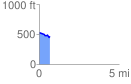
 0.667860 mi
 42.22 ft
 94.28 ft
 -52.05 ft
 2.67 %
GPX Downloads: Track Route
![]()
| at: |
Tombigbee National Forest - South |
show on map
animate
0.667860 mi
42.22 ft
94.28 ft
-52.05 ft
2.67 %