| at: |
Tombigbee National Forest - South |
Data from USFS GIS
 show on map
 animate
Trail users:


Elevation Profile
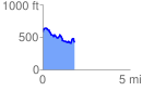
 1.809471 mi
 244.87 ft
 409.70 ft
 -164.83 ft
 4.29 %
GPX Downloads: Track Route
![]()
| at: |
Tombigbee National Forest - South |
show on map
animate
1.809471 mi
244.87 ft
409.70 ft
-164.83 ft
4.29 %