| at: |
Tombigbee National Forest - South |
Data from USFS GIS
 show on map
 animate
Trail users:


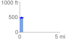
Elevation Profile
 0.427068 mi
 146.01 ft
 67.92 ft
 78.09 ft
 6.48 %
GPX Downloads: Track Route
![]()
| at: |
Tombigbee National Forest - South |
show on map
animate
0.427068 mi
146.01 ft
67.92 ft
78.09 ft
6.48 %