|
| at: |
Tombigbee National Forest - South |
Data from USFS GIS
 show on map
 animate
Trail users:


Elevation Profile
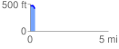
 0.312671 mi
 7.72 ft
 66.58 ft
 -58.85 ft
 4.03 %
GPX Downloads: Track Route
![]()
|
| at: |
Tombigbee National Forest - South |
show on map
animate
0.312671 mi
7.72 ft
66.58 ft
-58.85 ft
4.03 %