|
| at: |
Tombigbee National Forest - South |
Data from USFS GIS
 show on map
 animate
Trail users:


Elevation Profile
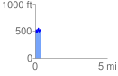
 0.373923 mi
 167.02 ft
 106.31 ft
 60.71 ft
 8.46 %
GPX Downloads: Track Route
![]()
|
| at: |
Tombigbee National Forest - South |
show on map
animate
0.373923 mi
167.02 ft
106.31 ft
60.71 ft
8.46 %