| at: |
Tombigbee National Forest - South |
Data from USFS GIS
 show on map
 animate
Trail users:


Elevation Profile
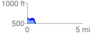
 0.759390 mi
 123.71 ft
 230.65 ft
 -106.95 ft
 5.75 %
GPX Downloads: Track Route
![]()
| at: |
Tombigbee National Forest - South |
show on map
animate
0.759390 mi
123.71 ft
230.65 ft
-106.95 ft
5.75 %