| at: |
Tombigbee National Forest - South |
Data from USFS GIS
 show on map
 animate
Trail users:


Elevation Profile
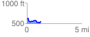
 1.286290 mi
 94.12 ft
 148.66 ft
 -54.54 ft
 2.19 %
GPX Downloads: Track Route
![]()
| at: |
Tombigbee National Forest - South |
show on map
animate
1.286290 mi
94.12 ft
148.66 ft
-54.54 ft
2.19 %