|
| at: |
Tombigbee National Forest - South |
Data from USFS GIS
 show on map
 animate
Trail users:


Elevation Profile
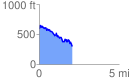
 2.055343 mi
 278.51 ft
 580.71 ft
 -302.20 ft
 5.35 %
GPX Downloads: Track Route
![]()
|
| at: |
Tombigbee National Forest - South |
show on map
animate
2.055343 mi
278.51 ft
580.71 ft
-302.20 ft
5.35 %