| at: |
Tombigbee National Forest - South |
Data from USFS GIS
 show on map
 animate
Trail users:


Elevation Profile
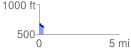
 0.256628 mi
 44.14 ft
 67.41 ft
 -23.27 ft
 4.97 %
GPX Downloads: Track Route
![]()
| at: |
Tombigbee National Forest - South |
show on map
animate
0.256628 mi
44.14 ft
67.41 ft
-23.27 ft
4.97 %