|
| at: |
Tombigbee National Forest - South |
Data from USFS GIS
 show on map
 animate
Trail users:


Elevation Profile
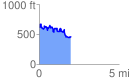
 2.000047 mi
 481.95 ft
 622.16 ft
 -140.21 ft
 5.89 %
GPX Downloads: Track Route
![]()
|
| at: |
Tombigbee National Forest - South |
show on map
animate
2.000047 mi
481.95 ft
622.16 ft
-140.21 ft
5.89 %