| at: |
Tombigbee National Forest - South |
Data from USFS GIS
 show on map
 animate
Trail users:


Elevation Profile
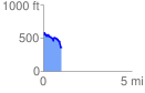
 1.035669 mi
 139.90 ft
 323.98 ft
 -184.07 ft
 5.92 %
GPX Downloads: Track Route
![]()
| at: |
Tombigbee National Forest - South |
show on map
animate
1.035669 mi
139.90 ft
323.98 ft
-184.07 ft
5.92 %