| at: |
Tombigbee National Forest - South |
Data from USFS GIS
 show on map
 animate
Trail users:


Elevation Profile
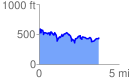
 3.768612 mi
 1010.14 ft
 1061.58 ft
 -51.44 ft
 5.34 %
GPX Downloads: Track Route
![]()
| at: |
Tombigbee National Forest - South |
show on map
animate
3.768612 mi
1010.14 ft
1061.58 ft
-51.44 ft
5.34 %