| at: |
Tombigbee National Forest - South |
Data from USFS GIS
 show on map
 animate
Trail users:


Elevation Profile
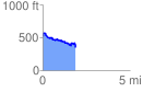
 1.894216 mi
 201.97 ft
 377.29 ft
 -175.33 ft
 3.77 %
GPX Downloads: Track Route
![]()
| at: |
Tombigbee National Forest - South |
show on map
animate
1.894216 mi
201.97 ft
377.29 ft
-175.33 ft
3.77 %