|
| at: |
Tombigbee National Forest - South |
Data from USFS GIS
 show on map
 animate
Trail users:


Elevation Profile
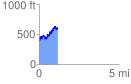
 1.204440 mi
 457.37 ft
 259.43 ft
 197.94 ft
 7.19 %
GPX Downloads: Track Route
![]()
|
| at: |
Tombigbee National Forest - South |
show on map
animate
1.204440 mi
457.37 ft
259.43 ft
197.94 ft
7.19 %