| at: |
Tombigbee National Forest - South |
Data from USFS GIS
 show on map
 animate
Trail users:


Elevation Profile
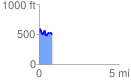
 0.821369 mi
 192.19 ft
 222.24 ft
 -30.05 ft
 5.12 %
GPX Downloads: Track Route
![]()
| at: |
Tombigbee National Forest - South |
show on map
animate
0.821369 mi
192.19 ft
222.24 ft
-30.05 ft
5.12 %