| at: |
Tombigbee National Forest - South |
Data from USFS GIS
 show on map
 animate
Trail users:


Elevation Profile
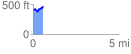
 0.595128 mi
 102.30 ft
 65.16 ft
 37.14 ft
 3.26 %
GPX Downloads: Track Route
![]()
| at: |
Tombigbee National Forest - South |
show on map
animate
0.595128 mi
102.30 ft
65.16 ft
37.14 ft
3.26 %