|
| at: |
Tombigbee National Forest - South |
Data from USFS GIS
 show on map
 animate
Trail users:


Elevation Profile
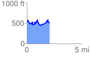
 2.088852 mi
 479.45 ft
 509.96 ft
 -30.50 ft
 4.62 %
GPX Downloads: Track Route
![]()
|
| at: |
Tombigbee National Forest - South |
show on map
animate
2.088852 mi
479.45 ft
509.96 ft
-30.50 ft
4.62 %